

























Severe thunderstorms heading this way

Here's a weather update from AEP:
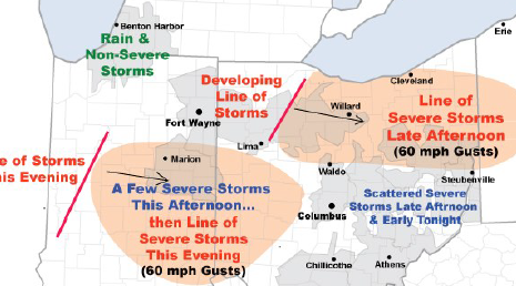
Severe thunderstorms containing damaging wind gusts to 60 mph will threaten portions of
AEP Ohio and I&M Power this afternoon into early tonight. A hot, humid, and increasingly unstable air mass is in place over the region. An approaching upper-level disturbance and cold front will trigger the storms.
AEP meteorologists have identified two elevated risk areas:
• Northeast Ohio...primarily from western Ohio across the Canton District. A line of thunderstorms should develop and intensify over western Ohio early this afternoon, then track east. Numerous wind gusts to 60 m.p.h. will be the main threat.
Additional thunderstorms will affect the region through the weekend, however the concern for more severe weather is low.
Stories Posted This Week
Tuesday, September 29, 2026
- September 29 Bluffton Schools athletics lineup, streaming
- Pirate volleyball sweeps Wapakoneta
- Pirate boys golf 4th at NWC tourney; Meyer places 2nd
- Pirate girls soccer shuts out Lima Central Catholic
- Pirate boys soccer shuts out Lima Central Catholic
- Pirate girls tennis blanks Kenton
- Bluffton Fall Festival overflows with family fun
- Stauber exhibit at Massillon Museum through November 1
- Arlington invites generations of alumni to all-school Homecoming
Monday, September 28, 2026
- Beavers sports roundup, September 21-27
- Alan K. Yoder, O.D., 86, owned Family Eye Care Clinic of Bluffton
- I-75 lane restrictions in Hancock County, Sept. 28-Oct. 2
- Travis Michael Swank, 40, was a salesman
- NetVUE panel highlights chaplaincy, vocation and meaningful work
- Bluffton Presbyterian hosts community-wide Socktober drive
Sunday, September 27, 2026
Saturday, September 26, 2026
Friday, September 25, 2026
- Ada Icon headlines, September 25
- Clay, community, and the classroom
- Pirate volleyball loss vs. Crestview
- Pirate girls soccer win vs. Allen East
- Janine Elizabeth (Minnich) Millager, 87, was a lab technician
- Send October 2026 calendar events to the Icon
- New time for Planning and Bluffton Beyond Tomorrow meetings, Sept 29
- Pirate boys golf 10th at sectionals
- Fall Festival activities are all over Bluffton, Sept. 26