


Forgotten Bluffton: What about those curves in the road?
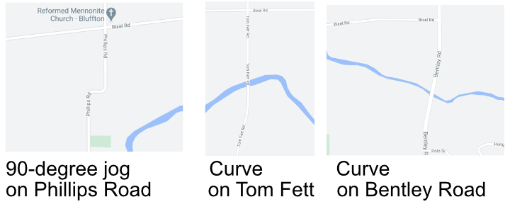
Why is there a “curve” on Bentley Road just north of Bluffton where the road crosses Riley Creek?
There’s also a curve on Tom Fett Road and on Phillips Road at about the same location.
On Phillips Road it's a serious twist, instead of being just a curve in the road. That’s because the Tom Fett and Bentley “jogs” have been modernized. Phillips remains the same at it was when it was originally laid out.
The simple answer to the question in the opening sentence is that the earth is round and that the early surveyors were trying to run straight lines on a sphere.
The little jogs are correction lines. As a result, every six miles the lines going straight north were corrected for the curvature of the earth with the resulting jog.
Originally, the Bentley and Tom Fett roads were 90 degree corrections. So, vehicular travel required an extreme reduction in speed at those jogs.
In the past 35 years as roads were widened and improved the jogs became curves thanks to the various county road departments.
On State Route 235 just south of U.S. 30, as you drive to Ada you’ll find another curve in the road. That curve, in the lifetime of viewers 65 and older, will also be remembered once upon a time as one of those 90 degree corrections. Image driving to Ada today and coming to an almost complete stop to navigate that jog that is now a curve.
The late Dr. Howard Raid, Bluffton University professor, explained this in greater detail in an essay in “Town at the Fork of the Riley’s.” That booklet was a collection of Bluffton historical stories put into one book in 1961 for the centennial of the Village of Bluffton.
Here’s what Dr. Raid wrote about those road jogs:
If you stop and analyze how you locate a spot on a sphere, you realize that you immediately run into some problems.
While you may run parallel lines one way around a sphere, it is impossible to run them both ways around a sphere and make them very meaningful.
The first attempt to describe property was merely by description. This method is called metes and bounds and is found as close to us as in Hardin County, several miles south of Ada.
In the Bluffton area, however, with the flat land and relative ease of laying out rectangular surveys a new method was instituted using as a base line certain straight lines. The first one of these is located three miles north of Pandora. At one time this road was known as the “Base Line Road.”
So, the next time you travel on Bentley Road north of Bluffton and travel past the curve at Riley Creek, remember that originally that curve was a 90-degree bend. And the curve is due to the curvature of the earth.
And, today, it’s simply a part of forgotten Bluffton.


Stories Posted This Week
Saturday, July 11, 2026
Friday, July 10, 2026
- Bluffton Sardines 3rd at WOAL swim meet after day 1
- Ada Icon headlines, July 10
- Orange Twp. receives ODOT request to close two US 30 intersections
- Find and update Bluffton Civic Organization contact information
- 12th Ride to Remember rolls through Bluffton July 11
- Rumpke trash and recycling guidelines for Bluffton, July 2026
- Beaverdam 4-H report for July 6
- Take a look at Blufftonicon.com/calendar (video)
- Newark Earthworks program on historical indigenous architecture, July 22
Thursday, July 9, 2026
- Ada Icon headlines, July 9
- Share the bridge
- Jeff Richards is new Bluffton Elementary principal
- Officer Dominic Francis Memorial Bike & Jeep Run, Aug. 8
- Sheriff seeks information in June 29 Meijer shooting investigation
- Down on the Farm celebration of America 250, July 19
- Enjoy this summer without doing damage
- Register now for July 23 Words and Wine event
- Village of Bluffton to serve BSC Community meal
Wednesday, July 8, 2026
- Allen County Auditor explanation of Ohio House Bill 186 Inflation Cap Credit
- Shoemaker sentenced to 27 years on child pornography charges
- St. John's UCC to host Bluffton bike swap
- Beaverdam Bunch reports: July 29 meeting
- July 28 speed puzzle competition at Bluffton Public Library
- Galley Book Group to meet at Bluffton Public Library
Tuesday, July 7, 2026
- Highway Patrol reports on July Fourth fatal crashes
- 2026 Porch Fest preview: Blanchard Creek Band, Conner Raines and AJ Knepper
- Take an RTA bus trip to Delphos on July 29
- Senior Center to host Route 66 Centennial trip
- Family-friendly Jurassic Adventure Escape Room, July 17 and 18
- Critters, Flitters, and Gallinippers: SCHS 2nd Saturday, July 11
- Register now for Bluffton Public Library's Read with a Dog