


AEP issues Tuesday weather alert
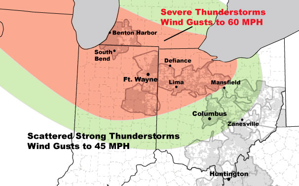
AEP provided the following weather alert for northwestern Ohio on Monday afternoon: Severe thunderstorms containing damaging winds will impact western Ohio overnight.
Upper level systems moving over a warm, moist air mass will develop a series of thunderstorms complexes over the next three days...one is currently moving through southern Ohio.
Another thunderstorm complex, with severe thunderstorms along the leading edge, will develop later today over the upper Plains and move to the east-southeast tonight, impacting Michigan, Indiana and Ohio early tomorrow morning. The main threat will be damaging wind gusts to 60 mph...small hail and frequent lightning.
These thunderstorms will continue to move to the southeast through central Ohio and weaken....no severe weather is expected for Columbus and Canton, but wind gusts to 45 mph are possible.
Forecasting the exact timing of thunderstorms is difficult, so peak threat times are provided below.
AEP Ohio:
Western Ohio District...Broken Line of Severe T-Storms (Gusts to 60 mph)..5 am to 8 am Tuesday, June 22.
Stories Posted This Week
Wednesday, July 2, 2025
Tuesday, July 1, 2025
Monday, June 30, 2025
Sunday, June 29, 2025
Saturday, June 28, 2025
- Community Pool closed June 28
- Weekend Doctor: About Rotator Cuff Repair
- WOAL Swim Champs in Wapakoneta July 11-12
- '60s Survivors Band plays fifth annual free concert
- Bluffton Lions to bring all-abilities playground to new Legacy Park
- July 2025 programs and services at Bluffton Public Library
- Save the date: July 17 Garden Club is all about herbs
- Bluffton Vacation Bible School, July 13-17 at Bluffton Y