


So far, so good...but low-impact winter storm heading our way
So far, so good. As winter in Bluffton goes.
Maybe that's about to change. The Bluffton snow plow crew is on alert for whatever may come our way this weekend.
Village administrator, Jamie Mehaffie updated The Icon on salt usage soo far this winter saying that the town has not needed to order any road salt.
However:
"While we had a slow start to the season, the recent smaller snow and ice events haveincreased our salt usage, he said. "As of Jan. 30, we are close to emptying the first bin of salt and have not started using the second bin, which is filled to capacity.
"The forecast for this weekend appears to indicate a potentially decent snow event that the Service Department is preparing for. Additionally, based on the extended forecast, whatever snow we get this weekend will most likely be around for a while.
"If the forecast holds true, I anticipate having the contractor remove the snow from the downtown area overnight on Monday night.
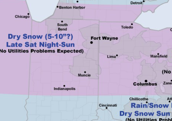
Here's a forecast from AEP:
Low pressure is expected to move across the Ohio Valley and intensify on Sunday bringing widespread snow to AEP Ohio service territory. While this storm will likely create widespread travel problems, it appears that this will be a low impact storm for the utilities.
Dry snow will fall in I&M Power late Saturday night-Sunday and northern and central AEP Ohio and Wheeling Power Sunday-Sunday night.
Temperatures will remain cold enough for dry, fluffy snow that will not stick to power lines. Across southern AEP Ohio & northern APCo temperatures will be closer to freezing on Sunday leading to a rain/snow mix.
Snowfall is not expected to be heavy enough to create utility problems and ice accumulations are not expected with this storm. The precipitation will end as dry snow as temperatures fall Sunday night.
Stories Posted This Week
Thursday, July 10, 2025
Wednesday, July 9, 2025
- Kimberly Lynn Stover worked for Bank of America
- July 17 Community Meal served by the Village of Bluffton
- Home cooling assistance program through Sept. 30
- July 17 Bluffton-Pandora garden club program on herbs
- Richland Twp trustees to hold budget hearing on July 14
- Bluffton Tax Budget hearing scheduled for July 14
- The Icon's menu mission
- Moser Woods honored by Ohio Forestry Association