


Forgotten Bluffton: Where is the earliest settled section of our village?
Where is the earliest settled section of Bluffton?
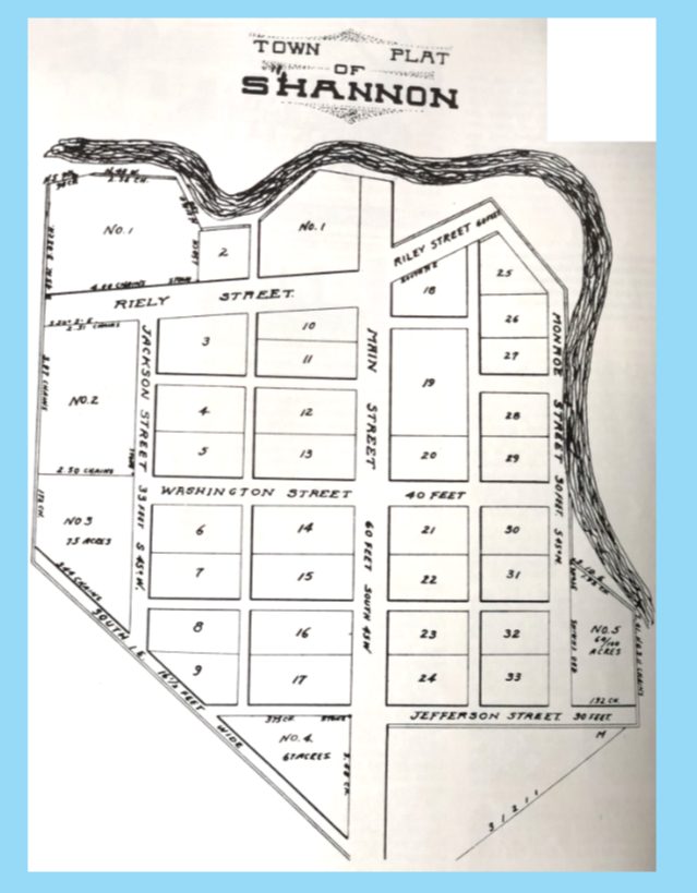
The map accompanying this story answers that question.
Bluffton was incorporated as a village in 1861, but it was 23 years prior to that, in 1838, when the first lots for the village were platted.
Joseph DeFord platted these lots. And, five years before that, in 1833, DeFord built the first home in what is now Bluffton – it was a log cabin. The mural in the Bluffton post office depicts a scene of the cabin under construction.
This cabin was located on the North Main and Riley streets, just southwest of the Main Street bridge.
DeFord also built the first grist mill, on the banks of Riley Creek. But, the village where we now live was not yet called Bluffton, as you will see later in this story.
Our next settler was Joseph Jones. On July 4, 1833, he purchased land from the United States government on the site of the current Bluffton High School. Why was is so far away from DeFord’s property? We don’t know.
The government land office was in Wapakoneta. This section of northwestern Ohio was the final part of the state to be open to European settlers. Prior to that it was part of the Shawnee native American reservation.
Although there were some traders and very early adventurers in this area, the land buyer records reveal the real influx of pioneers arriving from 1830 to 1850.
On May 7, 1852, a post office was established here named Croghan Post Office, Shannon, Ohio, in order to avoid confusion with a Shannon in the southern part of the state. The name of Croghan was selected in honor of Col. George Croghan who defended Fort Stephenson at Fremont in the War of 1812.
Now, examine the town plat map of Shannon. It was drawn up by DeFord. Notice the street names: Washington, Jefferson and Monroe, named after early U.S. presidents.
Monroe eventually was renamed Thurman and we will get to that in a future column.
Also, notice Riley Street is “Riely Street” on DeFord’s map.
And finally look at the plat numbers. From this group you can see where the first lots were created. Number 1, is at the corner of Main and Riley.
As an additional piece of information, you will notice that surnames of early village pioneers are not Swiss. The Swiss were farmers and settled in what became the rural area between Bluffton and Pandora.
The other European settlers, mainly English, Scott and Irish were persons with trades and skills. They tended to settle inside the village where they developed their crafts.
As a footnote to this town plat, DeFord’s Main Street is not laid out north and south, but rather northwest and southwest.
Why? Because he laid it out following a native American trail. One assumption is that the native Americans, as hunters, followed an already well-worn animal trail. If that is the case, Main Street Bluffton could be following a path that is hundreds of years old.
Look at the way we've posted the 1838 map below - in a true north and south direction.
Today, this information is part of forgotten Bluffton.

Stories Posted This Week
Thursday, July 17, 2025
- Cross is Champion in three 2025 State Fair riding events
- July 21 planning commission items include Vine St. closure for practice field
- Forky asks a question: Can a new diet result in significant changes?
- July 22 Twin Town event with Mindelheim, home of GROB-Werke
- Sign up for Bluffton's Got Talent at Bluffton Public Library