


Bluffton in path of potential severe thunderstorms
AEP meteorologists anticipate severe thunderstorms containing damaging winds the Icon readership area later today. Here's AEP's announcement:
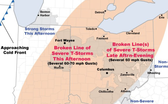
A cold front in Illinois will move into I&M Power just as an upper-level disturbance (now over Missouri) arrives. Ample sunshine & humidity will generate moderate instability by afternoon as temperatures reach the low-mid 80s.
Expect a broken line of severe storms to organize over Indiana midday...then cross eastern I&M Power (Ft. Wayne, Muncie) early this afternoon.
A broken line (or lines) of severe storms will continue through AEP Ohio mid-afternoon through evening. While widespread damaging winds are not expected...scattered damaging wind gusts of 60-70 m.p.h. will be problematic for the utilities. Thunderstorms should weaken before reaching Wheeling, W.V. after dark.
Today’s threat includes several large population centers such as Ft. Wayne, Columbus, and Canton. By tomorrow...more tranquil weather should return to Ohio and I&M Power.

Stories Posted This Week
Monday, June 15, 2026
Sunday, June 14, 2026
Saturday, June 13, 2026
Friday, June 12, 2026
- Ada Icon headlines, June 12
- Blanchard River Watershed Partnership hosts 5K trail run on July 25
- Beaverdam to begin water treatment plant repairs
- Save the date: Declaration of Independence reading, July 8
- Bluffton Police answer 630 calls for service in May 2026
- Great wealth disparity and our eroding democracy
Thursday, June 11, 2026
- Ada Icon headlines, June 11
- Splitting headache: Fasting and migraines
- Pamela Ann Bricker was a social worker
- Bluffton Community Garage Sales, June 18-19-20
- Open and improved Elm St. segment
- Ultimate car seat guide recommended by Bluffton police
- Senior Center's June community meal shifts to summer schedule