


Watch those skies today - damaging winds anticipated tonight
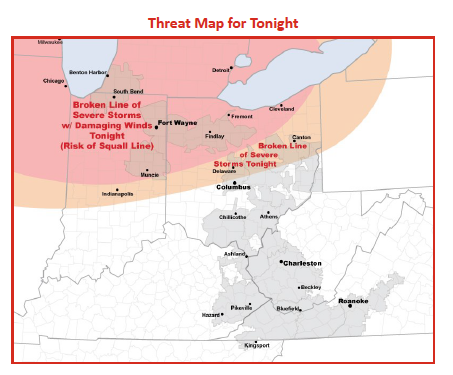
AEP provided The Icon with the following weather alert for today and Tuesday (June 22-23).
Two rounds of severe thunderstorms are expected to impact northwestern Ohio
this afternoon and tonight. Both rounds have the potential to cause widespread wind damage.
Round 1 This afternoon-early evening: At 9 a.m. radar shows a complex of severe thunderstorms racing across eastern Minnesota/eastern Iowa. This will reach northern Indiana as a squall line (gusts up to 80 mph) early this afternoon.
Significant utilities problems are possible. The main part of the line is expected to stay north of the Fort Wayne District and western Ohio late this afternoon-evening, but some pockets of damage are expected.
Round 2 Tonight: Another complex of severe storms is expected to develop over Wisconsin/Iowa/northern Illinois late this afternoon and move across northern Ohio tonight.
In the wake of the first complex of storms, there is uncertainty regarding the evolution and coverage of the next round of storms tonight. With very humid, unstable air and unseasonably strong winds aloft
AEP meteorologists expect at minimum that a broken line of severe storms will move
into northern Ohio. Potential does exist for a squall line (gusts up to 80 mph) to form. If a squall line indeed develops, significant utilities problems would result. I&M Power’s Michigan & South Bend/Elkhart Districts are most at risk, but the rest of I&M Power and northern AEP Ohio are also at risk overnight.

Stories Posted This Week
Saturday, June 6, 2026
Friday, June 5, 2026
- Stay tuned for Pirate action at OHSSA state track and field coverage
- Ada Icon headlines, June 5
- Wheeler graduates from Ohio Bankers League Bank Leadership Institute
- Ellerbrock awarded Lima Memorial Nursing Alumnae Scholarship
- Pirate speedsters Wright and Miller each advance to 2 state finals
- Golfers, sponsors invited to support American Legion fundraiser
- Letter: Alternatives to Village mosquito fogging
Thursday, June 4, 2026
- Eileen Ruth Garmatter was a homemaker
- Elnore Ruth (Rosenberger) Yost taught at Marimor
- WGTE and WBGU create broadcasting partnership
- ICYMI: May 2026 Bluffton Icon Highlights
- Shoppers' journey with Bluffton Small Business Passport has begun
- Middle and high school student activities at BPL
- Local artist Crumrine to teach Watercolor Workshop at Library
- Lacrosse or La Crosse: Game versus virus
- 2027 Senior Center trip planning, June 11
Wednesday, June 3, 2026
Tuesday, June 2, 2026
- Cory-Rawson High School honor roll for fourth quarter, 2025-2026
- Bluffton High School 4th Qtr. Honor Roll for 2025-2026
- June 4 Business Collective speed networking event
- K-2 students invited to weekly dinosaur adventures
- Library program explores indigenous agriculture and heirloom seeds
- May 2026 land transfers in the Bluffton school district
- Register June 18-19-20 garage sales with Bluffton Chamber
- Create a Bike & Flowers painting at BPL