


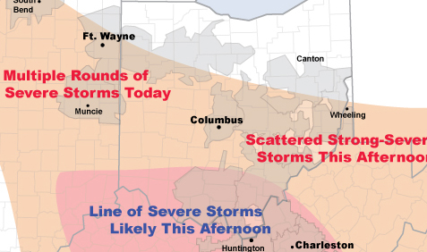
AEP warns of severe thundershower threat
Western Ohio (west areas only)
Multiple Rounds of Strong-Severe Storms
(50-60 mph 9am-3pm)
Severe thunderstorms will impact AEP's East Utilities Tuesday, July 24.
This morning radar showed a line of severe thunderstorms moving southeast through I&M Power. This line of storms was producing wind gusts of 60 m.p.h.
Elsewhere, radar showed numerous showers and non-severe thunderstorms across much of the region.
By late afternoon a more significant line of severe thunderstorms may take shape across southern Ohio. This line of storms would move south across Kentucky Power and APCo producing damaging wind gusts.
If a line of storms does develop a fairly significant outage event could ensue for southern Ohio, Kentucky Power and APCo.
Note: Times below are for the peak severe weather threat. Additional
showers & thunderstorms can be expected throughout the day.

Stories Posted This Week
Saturday, July 11, 2026
Friday, July 10, 2026
- Bluffton Sardines 3rd at WOAL swim meet after day 1
- Ada Icon headlines, July 10
- Orange Twp. receives ODOT request to close two US 30 intersections
- Find and update Bluffton Civic Organization contact information
- 12th Ride to Remember rolls through Bluffton July 11
- Rumpke trash and recycling guidelines for Bluffton, July 2026
- Beaverdam 4-H report for July 6
- Take a look at Blufftonicon.com/calendar (video)
- Newark Earthworks program on historical indigenous architecture, July 22
Thursday, July 9, 2026
- Ada Icon headlines, July 9
- Share the bridge
- Jeff Richards is new Bluffton Elementary principal
- Officer Dominic Francis Memorial Bike & Jeep Run, Aug. 8
- Sheriff seeks information in June 29 Meijer shooting investigation
- Down on the Farm celebration of America 250, July 19
- Enjoy this summer without doing damage
- Register now for July 23 Words and Wine event
- Village of Bluffton to serve BSC Community meal
Wednesday, July 8, 2026
- Allen County Auditor explanation of Ohio House Bill 186 Inflation Cap Credit
- Shoemaker sentenced to 27 years on child pornography charges
- St. John's UCC to host Bluffton bike swap
- Beaverdam Bunch reports: July 29 meeting
- July 28 speed puzzle competition at Bluffton Public Library
- Galley Book Group to meet at Bluffton Public Library
Tuesday, July 7, 2026
- Highway Patrol reports on July Fourth fatal crashes
- 2026 Porch Fest preview: Blanchard Creek Band, Conner Raines and AJ Knepper
- Take an RTA bus trip to Delphos on July 29
- Senior Center to host Route 66 Centennial trip
- Family-friendly Jurassic Adventure Escape Room, July 17 and 18
- Critters, Flitters, and Gallinippers: SCHS 2nd Saturday, July 11
- Register now for Bluffton Public Library's Read with a Dog