


Severe thunderstorms heading this way
Here's a weather update from AEP:
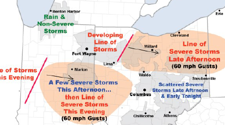
Severe thunderstorms containing damaging wind gusts to 60 mph will threaten portions of
AEP Ohio and I&M Power this afternoon into early tonight. A hot, humid, and increasingly unstable air mass is in place over the region. An approaching upper-level disturbance and cold front will trigger the storms.
AEP meteorologists have identified two elevated risk areas:
• Northeast Ohio...primarily from western Ohio across the Canton District. A line of thunderstorms should develop and intensify over western Ohio early this afternoon, then track east. Numerous wind gusts to 60 m.p.h. will be the main threat.
Additional thunderstorms will affect the region through the weekend, however the concern for more severe weather is low.

Stories Posted This Week
Saturday, June 6, 2026
Friday, June 5, 2026
- Stay tuned for Pirate action at OHSSA state track and field coverage
- Ada Icon headlines, June 5
- Wheeler graduates from Ohio Bankers League Bank Leadership Institute
- Ellerbrock awarded Lima Memorial Nursing Alumnae Scholarship
- Pirate speedsters Wright and Miller each advance to 2 state finals
- Golfers, sponsors invited to support American Legion fundraiser
- Letter: Alternatives to Village mosquito fogging
Thursday, June 4, 2026
- Eileen Ruth Garmatter was a homemaker
- Elnore Ruth (Rosenberger) Yost taught at Marimor
- WGTE and WBGU create broadcasting partnership
- ICYMI: May 2026 Bluffton Icon Highlights
- Shoppers' journey with Bluffton Small Business Passport has begun
- Middle and high school student activities at BPL
- Local artist Crumrine to teach Watercolor Workshop at Library
- Lacrosse or La Crosse: Game versus virus
- 2027 Senior Center trip planning, June 11
Wednesday, June 3, 2026
Tuesday, June 2, 2026
- Cory-Rawson High School honor roll for fourth quarter, 2025-2026
- Bluffton High School 4th Qtr. Honor Roll for 2025-2026
- June 4 Business Collective speed networking event
- K-2 students invited to weekly dinosaur adventures
- Library program explores indigenous agriculture and heirloom seeds
- May 2026 land transfers in the Bluffton school district
- Register June 18-19-20 garage sales with Bluffton Chamber
- Create a Bike & Flowers painting at BPL